Satellite Orbits
If you take a look at the Satellite Tracker 3D visualization, you’ll find that satellites orbit in a variety of ways. They move in lots of different directions and are positioned at different altitudes above Earth.
The parameters of a satellite’s orbit determines a lot about the measurements it can make. Two of the key parameters for an orbit are its inclination and its altitude. We’ll explore those here.
Inclination
The inclination of an orbit is an angle that it makes with the equator. One of the main results of the inclination is the maximum latitude the satellite track will cover on the planet - a higher inclination will reach higher latitudes.
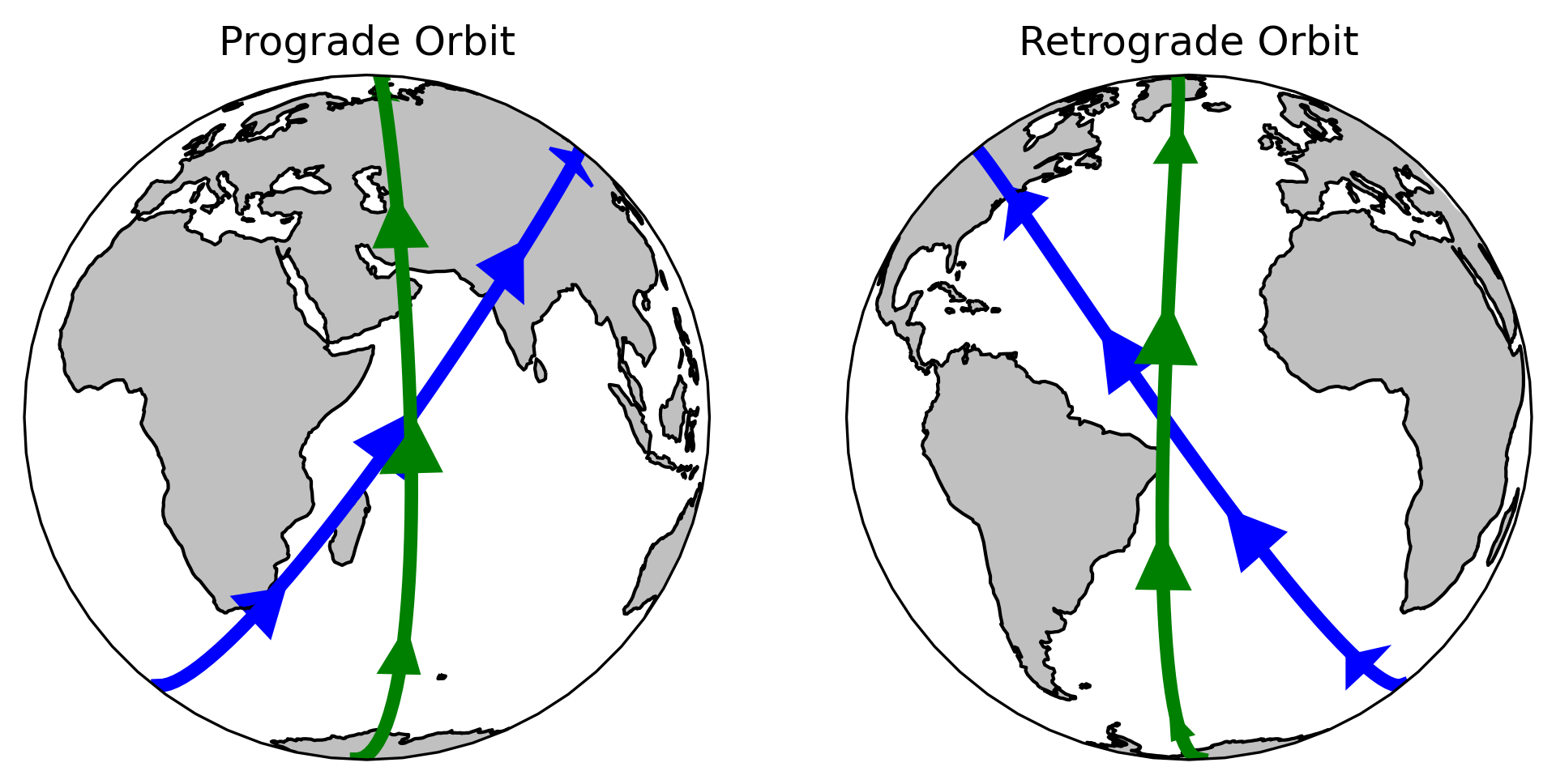
Orbits with a positive inclination (0° to 90°) are called prograde orbits and the satellite will travel in the same direction as the Earth rotates. By contrast, orbits with an inclination in the range 90° to 180° (equivalently expressed in the range -90° to -0°) are retrograde orbits and travel in the opposite direction as the Earth rotates. We can visualize these orbits in an orthographic projection in the following image:
These same orbits trace out the following paths in a Plate Carree projection:
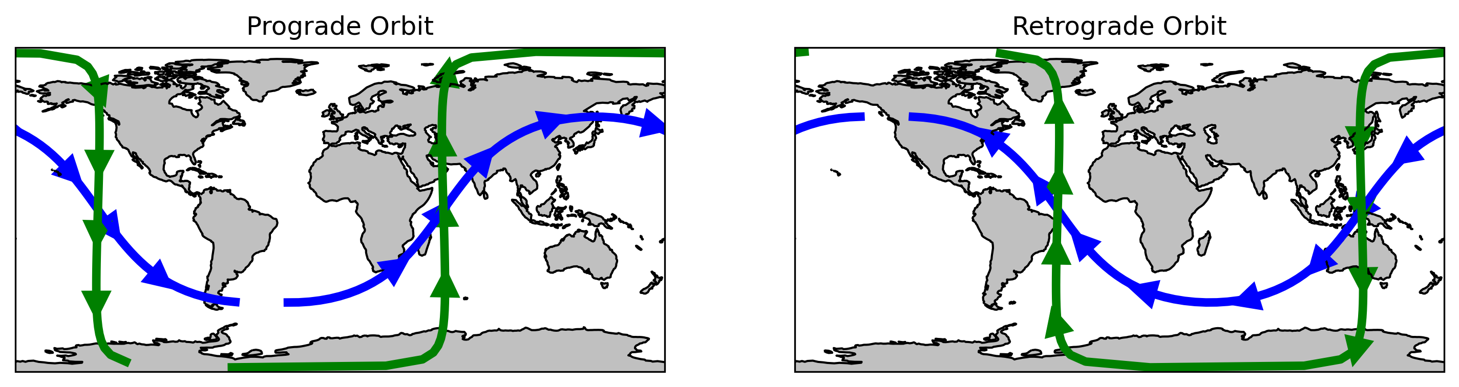
The blue orbits in these plots have inclinations of ±51.6° while the green orbits have inclinations of ±88°. These inclinations represent the prograde orbit of the International Space Station (ISS) and the retrograde orbit of the ICESat-2 satellite (92°). The ISS maintains a shallow orbit to fly over most of the populated areas of the planet; the ICESat-2 satellite maintains a near-polar orbit to cover the majority of the ice-covered regions of the poles.
Altitude
The altitude at which a satellite orbits above the Earth is important in determining how long it takes to complete one trip around the planet.
The acceleration an object feels as a result of gravity is
where is the universal gravitational constant, is the mass of the Earth, and is the distance from the center of Earth to the satellite. In orbit, the acceleration due to gravity is balanced by centripetal acceleration given by
Setting these two equal and solving for yields
Using this equation, we can determine some typical orbit parameters for commonly-used satellites.
Check Your Understanding
The Earth rotates at a rate of one 360° rotation every 23 hours, 56 minutes, and 4 seconds (a sidereal day, less than 24 hours!). At a radius of 6400 km, how fast are you moving through space? If a satellite is moving at the same speed, it would always be over the same spot on Earth - this is a geostationary satellite orbit. What is the altitude of a geostationary satellite?
For reference, the GEO-West satellite orbits at an altitude of 35,786 km while the Landsat-9 satellite orbits at an altitude of 705 km. See if you can find these in the satellite tracker!
Resolution
The resolution of satellite imagery is described in terms of three different parameters - spatial, temporal, and spectral.
Spatial Resolution
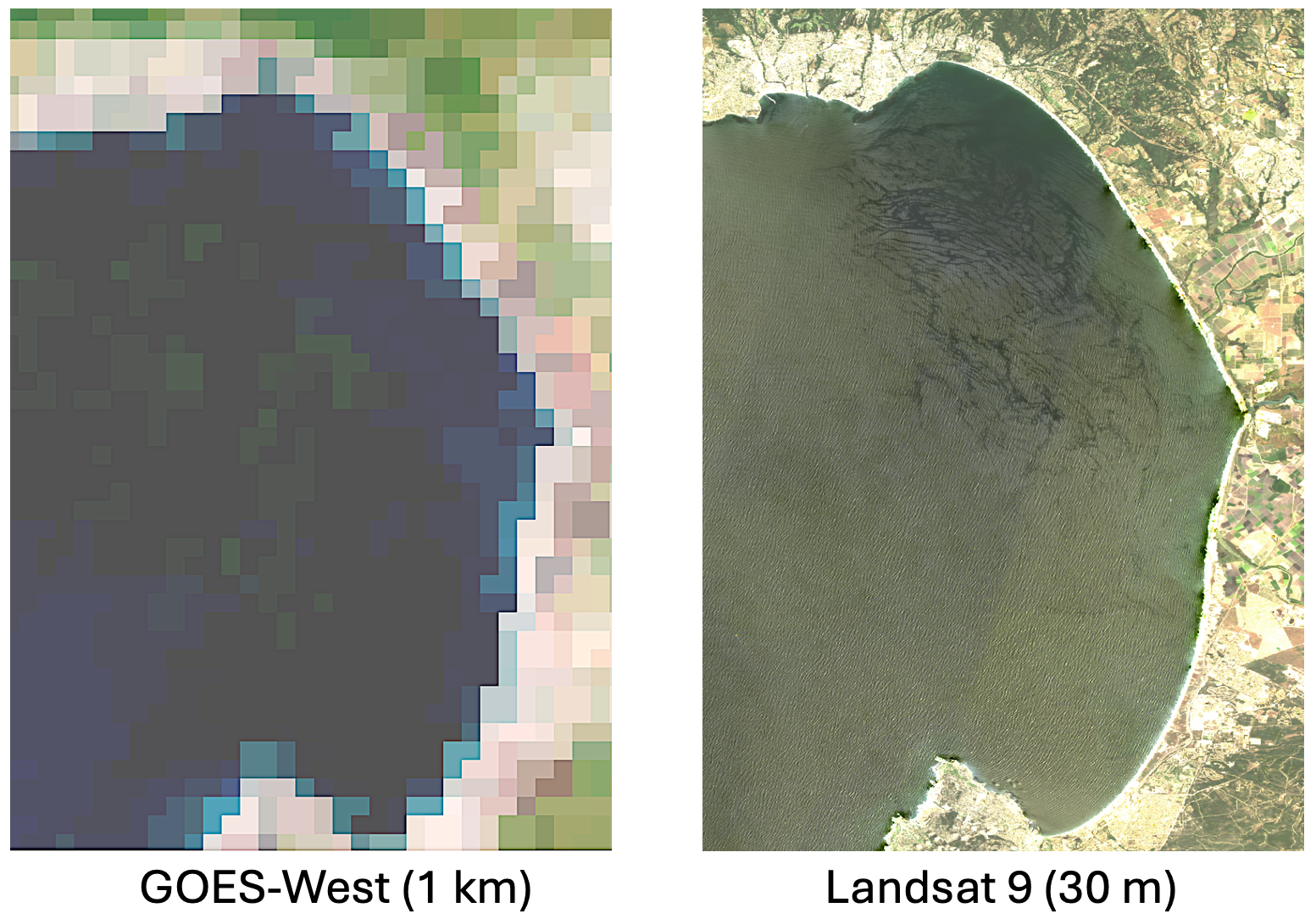
The spatial resolution of satellite imagery refers to the area on the Earth’s surface which makes up each pixel in the satellite image. Consider the following comparison of resolutions between the GOES-West geostationary satellite and the Landsat 9 satellite over Monterey Bay:
The Rayleigh Criterion
The spatial resolution of a satellite image is limited by the Rayleigh Criterion which says
Here, represents the minimum resolvable angular separation between two features in radians. On the right-hand side, is the wavelength of light being observed and is the diameter of the telescope.
This limitation occurs because when light passes through an aperture, it doesn’t form a single point. Rather, due to diffraction, it forms an Airy disk -- the smallest focal spot of light that an optical system can create.
There are three implications of the Rayleigh Criterion for the resolution of satellite data:
Resolution will generally decrease as wavelength increases ( increases as increases). For example, using the same sensor, optical data will have higher resolution than thermal data, which in turn will have higher resolution that microwave data. We will see examples of these in the coming notebooks.
A bigger telescope or antenna reduces diffraction spreading, allowing the satellite to distinguish smaller features on Earth ( decreases as increases).
The distinguishable ground distance between two points i a satellite measurement, computed as will increase with altitude (assuming the same sensor). We see this by substituting into the equation above to obtain . From here, we see that increases as increases.
Temporal Resolution
The temporal resolution of a satellite refers to the timespan between when the satellite makes repeated measurements of the same location. The temporal resolution is determined by its orbit parameters. Typically, orbits are designed to exactly repeat the same ground tracks at the same time of the day. This allows for a consistent comparison between two satellite images acquired on different days to limit the need to account for changes in sun angle, shadows, etc.
For reference, the Landsat 9 and MODIS-Aqua satellites have a repeat pass of 16 days. However MODIS has a wide swath (2330 km) giving full coverage of the Earth every 1-2 days while Landat-9 has a thinner swath (185 km) so complete coverage takes longer. The GOES-West satellite, by contrast, is a geostationary satellite and therefore has continuous monitoring of the same location but does not see other parts of the Earth.
Spectral Resolution
The spectral resolution of a satellite observation refers to the portion of the electromagnetic spectrum in which the satellite collects data. For example, the Landsat 8 satellite collects optical imagery in 11 bands while the MODIS satellite collects optical imagery in 36 bands. Compare these bands in the following diagram:
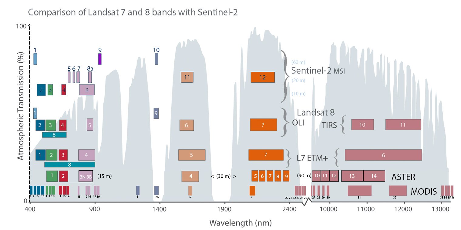
As we can see, Landsat and MODIS collect information at different but overlapping regions of the electromagnetic spectrum.